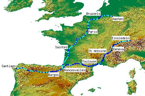
Medieval Itineraries: Künig von Vach

Hermannus Künig von Vach was a monk in the Servite community in Vach, a small town on the Hesse/Thuringia border NE of Fulda now called Vacha-an-der-Werra. His guidebook to the road to Santiago, Die Walfart und Straß zu sant Jacob, was published in 1495. It became popular and went through several editions, including a translation in 1518 into Low German De overen und meddelen Straten van Brunswygk tho Sunte Jacob in Galicien tho Compostella. In 1899 Konrad Haebler produced a new edition under the title Das Wallfahrtsbuch des Hermannus Künig von Vach und die Pilgerreisen der Deutschen nach Santiago de Compostela.
His own pilgrimage probably took him to and from Vacha, but the book describes a route from Einsiedeln via La Motte and Toulouse - which he called the Oberstrasse, upper road - and back via Paris and Brussels to Aachen - the Niederstrasse or lower road. It seems that the reason for the names had nothing to do with contours, but was simply because the maps of the time (before Mercator) had south at the top, so the Einsiedeln route was the 'upper road' and the Aachen one the 'lower road'. He seems to have disliked climbing, as he recommends using lower-level roads to bypass the 2 highpoints on the Camino Francés, the Cruz de Ferro and O Cebreiro, and on the way back appears to have used the direct route from Pamplona to Bayonne via the Baztan valley rather than going over the Roncesvalles pass.
The Oberstrasse is far more detailed than the Niederstrasse and, although the guide generally gives distances between towns in leagues, these are missing for the Bordeaux-Paris section, which implies that the author may not have been personally familiar with it. At Burgos on the return route, he mentions an alternative to the left via 'Porten berge', presumably the St Adrian tunnel, 26 leagues, and to the right to 'San Niclass' and Strassburg. This latter is rather puzzling, and recent editors have suggested it may be in the wrong place, belonging instead to the reference in the Loire valley to a route to the Lorraine towns of 'Widerssdorff' (Vergaville near Dieuze) and Metz; in this case, 'San Niclass' may mean the shrine town of St Nicolas de Port/Varengeville near Nancy.
More details
spreadsheet | detailed map (130 placemarks)External resources
- An English translation of the guide by John Durant, ''The Pilgrimage and Path to St James'', is published by the Confraternity of St James
- A translation into modern German, Die Straß zu Sankt Jakob, by Klaus Herbers and Robert Plötz is published by Thorbecke
- A translation of this latter into Galician is available for free download from the Consello Cultural de Galicia site
- The Haebler edition is available on the Internet Archive