Medieval Itineraries: Charles Estienne
Although Charles Estienne is best known for his works on anatomy, his interest for pilgrims is his La Guide des Chemins de France, the first comprehensive inventory of French roads, originally published in 1552. In 1551 he had taken over the family printing business from his brother Robert and been appointed king's printer. He was therefore able to publish the Guide himself.
Unlike Etzlaub in Nürnberg with his Romweg-Karte, he did not attempt to draw a map of France, but instead split the country into regions, with a brief description of the region and a catalogue of the roads in it. Distances between places are given in leagues (3.25km) and also in days travel, and there are notes on places to stay, castles, churches, and other items of interest to the traveller. He also leaves plenty of space for readers to add their own notes in the margin.
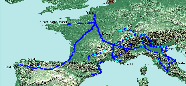
At the end of the foreword to the 1st edition, he says he has information on the rivers and on the roads to holy places, but has decided not to include these in this 1st edition. However, due to popular demand, he soon produced a 2nd edition, which included the list of rivers, Les Fleuves du Royaume de France. He also produced a separate volume, Les Voyages de plusieurs endroits de France : & encores de la terre Saincte, d'Espagne, d'Italie & autres pays which contained the pilgrim roads (and also the rivers). This lists the roads to 37 shrines not mentioned in the main book. These are mainly in France, some of them now lost in obscurity, but there are also routes (plotted here) to Montserrat, Loreto, Rome (7 routes), Santiago, and Oviedo, plus others (not plotted here) to Jerusalem and Constantinople. Because the Voyages is a supplement to the main Guide, several of the routes in the former refer to routes in the latter, so I also plan to plot these, and also those routes in the main Guide that are used by other itineraries or that correspond to modern routes. This is however a lot of work, so no promises on when I'll get around to this.
Estienne does not appear to have been a successful businessman, as he went bankrupt in 1561. The Guide, though, was taken over by other publishers, such as Rigaut in Lyon, and Daré in Rouen, and became widely available. Jean Bonnerot produced an annotated edition with maps in 1936, which was reprinted in 1978.
More details
spreadsheet | detailed map (553 placemarks)External resources
- the 1553 edition with both volumes together is available on the website of the Douglas H. Gordon Collection at the University of Virginia. Because sections of the copy they have were bound in the wrong sequence, they have two versions available: as is, and a corrected online version with pages in the correct order. The original edition comes first, and the Voyages are images 286-361. The roads to Rome are images 331-48, and that to St Jacques 348-52. There is a Table des voyages on image 399.
- the first edition is available on the BNF's Gallica site